
Global Water Futures Observatories a critical step towards water security for Canadians
When the University of Saskatchewan (USask) set out to lead the pan-Canadian Global Water Futures (GWF) Program in 2016, it laid the groundwork for what has become an integrated system of research stations across the country that are critical to understanding, predicting and tracking the health of our water.
By Mark FergusonNow six years on, GWF is the largest and most published university-led freshwater research program in the world and includes 213 faculty investigators, 531 end-users, 1,826 new researchers, and a network of 23 Canadian universities working on 65 projects and core teams.
The program has also established or operates 76 water observation sites, 27 deployable measurement systems, and 31 state-of-the-art university-based environmental and aquatic analysis facilities.
These facilities monitor things like algae activity in freshwater lakes that are the drinking water source for millions of people; snowpacks and glaciers in the high Canadian Rockies that feed the rivers and streams of western North America and can contribute to catastrophic flooding; the health of the Great Lakes and contaminants in groundwater used as drinking water sources for Indigenous communities.
Thanks to new funding from the Canada Foundation for Innovation (CFI) Major Science Initiatives (MSI), these critical research stations and their data management system will continue to operate under the GWF umbrella as the Global Water Futures Observatories (GWFO).
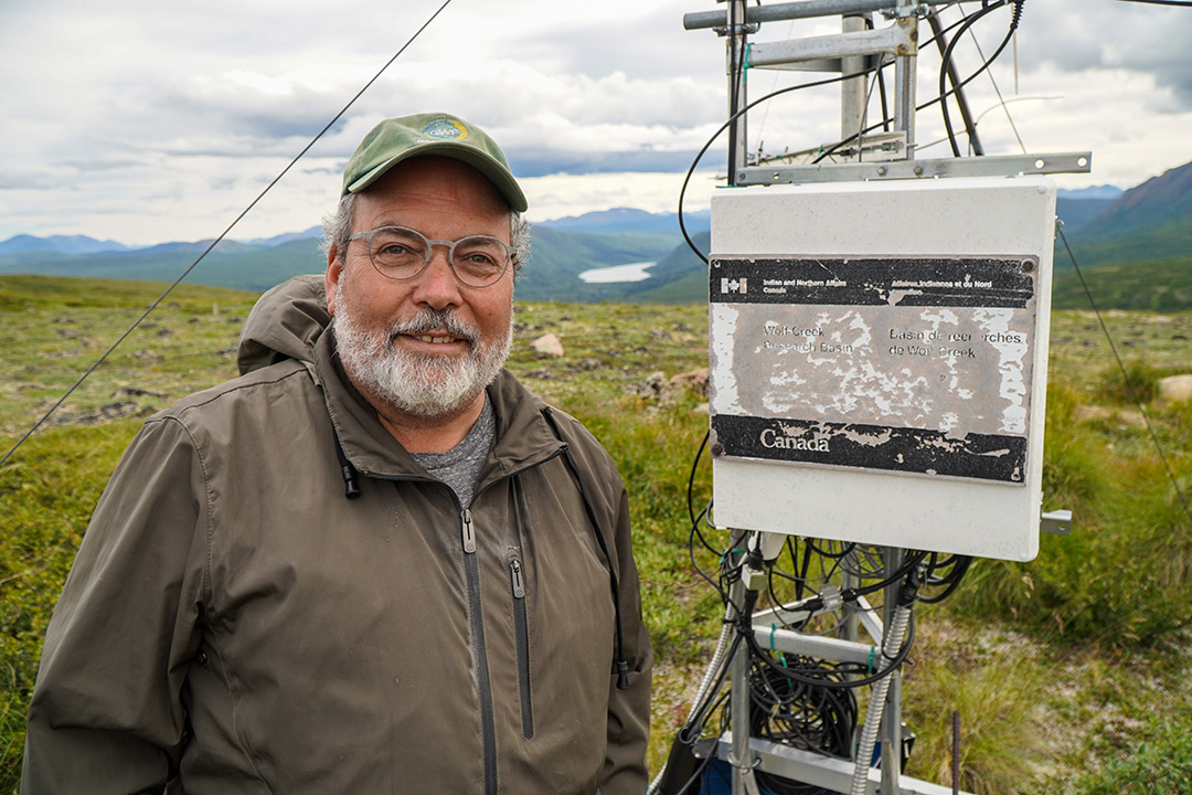
“This funding means the observational core of Global Water Futures will carry on to at least 2029. Thee tremendous heritage of observations that go back to the early 1960s at Canadian hydrological research basins will continue to be honoured and maintained as sources of science for our professors, places to train our graduate students, and places to test our models and make new discoveries about the changing hydrology in Canada, from the Arctic down to the Great Lakes,” said Dr. John Pomeroy (PhD), USask distinguished professor and director of GWF, and the Canada Research Chair in Water Resources and Climate Change.
“The observations will help us to continue to develop solutions to manage and conserve Canada’s water supplies and major rivers.”
GWFO provides data to provide early warning and test beds for predictions of flood, drought, and water quality issues, and operates across seven provinces and territories, including the Great Lakes Basin.
USask leads the nine-university collaboration that operates the network to monitor and help support the development of solutions for the impending water crisis that Canadians face due to climate change, inadequate water management, the proliferation of toxic contaminants, and environmental degradation.
The announcement of $15.25 million in funding for the $40.4 million GWFO came in late August along with several other USask projects, including $2.6 million for SuperDARN Canada, $53.9 million for the Vaccine and Infectious Disease Organization (VIDO), and $97 million for the Canadian Light Source (CLS).
A list of the 76 stations across Canada:
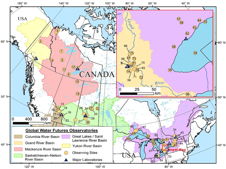
GWFO Field Observation Sites grouped by major water drainage basin
Yukon River Basin
- Wolf Creek Research Basin
- Tombstone Water Observatory
Mackenzie River Basin
- Havikpak Creek Research Basin
- Inuvik to Tuktoyaktuk Highway
- Smith Creek
- Kakisa and Tathlina Lakes
- Bogg Creek and surround areas
- Trail Valley Creek Research Basin
- Baker Creek Research Basin
- Peace-Athabasca Delta / Wood Buffalo National Park
- Dehcho Lake Sampling Network
- Fire Ecology Network
- Athabasca Glacier Research Basin
- Britnell-Bologna Icefield
- Fort McMurray
Saskatchewan-Nelson River Basin
- Helen Creek Research Basin
- Marmot Creek Research Basin
- Sibbald Research Wetland
- Peyto Glacier Research Basin
- Burstall Creek Research Basin
- Kenaston / Brightwater Creek Mesonet Site
- Saskatchewan River Delta
- Fortress Mountain Research Basin
- St. Denis National Wildlife Area
- Fen - Boreal Ecosystem Research and Monitoring Sites (BERMS), White Gull Creek Basin
- Old Jack Pine (OJP) - Boreal Ecosystem Research and Monitoring Sites (BERMS), White Gull Creek Basin
- Old Black Spruce (OBS) - Boreal Ecosystem Research and Monitoring Sites (BERMS), White Gull Creek Basin
- Clavet Livestock and Forage Centre of Excellence
- Borden Bridge
- Buffalo Pound Lake
Columbia River Basin
- Columbia Icefield
Great Lakes / St. Lawrence River Basin
- Georgian Bay Biosphere
- Turkey Point Sites
- Gatineau River and Saint-Maurice River watersheds, QC
- Turkey Lakes Watershed
- Eastern Basin Lake Erie
- Fanshawe Reservoir
- Lake Ontario - Hamilton Harbor
- Lake Ontario - Western Basin
- Lake Ontario - Pointe Peter array
- Lake Ontario - Rideau Canal - section-1
- Lake Ontario - Rideau Canal - section-2
- Lake Ontario - Rideau Canal - section-3
- Lake Ontario - Eastern Basin
- Lake Ontario - Salmon River
- Lake Superior - Western Arm
- Lake Superior - Nipigon Bay
- Lake Superior - Black Bay
- Lake Superior - Thunder Bay
- Lake Huron - Cisco north channel project
- Lake Huron - Algonquin Park
- Lake Huron - Lake Whitefish / glider calibration for telemetry
- Lake Erie - Detroit River acoustic array
- Lake Erie - Pigeon Bay
- Urban Ecohydrology 1: Ajax Sewersheds (East & West)
- Urban Ecohydrology 2: Richmond Hill stormwater pond
- Urban Ecohydrology 3: Lake Wilcox (Richmond Hill)
- Urban Ecohydrology 4: Bioretention cell (Mississauga)
- Urban Ecohydrology 5: Stormwater ponds (Kitchener)
- CFB Borden Site
- Hopewell Creek, southern ON
- Wilket Creek, Toronto
- Morningside Creek, Toronto
- Ganatsekaigon Creek, Pickering
- Blair Creek, Kitchener
- Inverhaugh
- West Montrose
- Kiwanis Park
- EIT
- Fairway
- Manheim
- Glen Morris
- Strawberry Creek
- Alder Creek Smart Watershed
- Elora Research Station (University of Guelph)
- rare Charitable Research Reserve