
Space weather
University of Saskatchewan researchers monitoring near-Earth space environment to mitigate weather and security threats
By GLOBE and MAIL EXCELLENCE IN RESEARCH AND INNOVATION REPORTThe local weather forecast tells us if we need to bundle up or bring an umbrella. National and global reports alert us to instances of extreme weather – and the need for assistance in affected regions. But what about the weather in space? How do events like solar wind – originating at a distance of about 150 million kilometres – affect our daily lives?
"Studies show that solar storms can cause massive problems. The worry is that a big one will knock out the power systems that our modern society so highly depends on," says Glenn Hussey, principal investigator and director at the Super Dual Auroral Radar Network (SuperDARN) Canada. "We could be in the dark for weeks or months."
In addition to impacting power grids, solar activity like flares and coronal mass ejections can degrade pipelines, disrupt or damage satellites, interfere with navigation and communication signals and endanger high-altitude air travel, which makes predicting and mitigating these effects critical, says Dr. Hussey, adding that this is part of SuperDARN's objective: to provide scientific insights into space weather to help guard against detrimental impact.
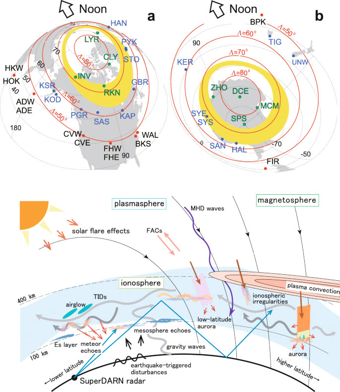
SuperDARN Canada, headquartered in the Institute of Space and Atmospheric Studies (ISAS) at the University of Saskatchewan (USask), is Canada's contribution to the SuperDARN program, a global network of scientific radars monitoring conditions in the near-Earth space environment.
There is a clear link between "studying the physics interactions that happen at the boundary between the atmosphere and space – and understanding the outcomes," says Daniel Billett, assistant director at SuperDARN Canada. "We're ionospheric physicists who conduct fundamental research. We run the radars and gather the data. From there, we collaborate with people who use this information to model forecasting – or to mitigate effects like power outages or satellite signal disruptions."
A legacy of leadership
2025 marks the 30th anniversary of the SuperDARN program, which officially started in 1995 with the signing of the principal investigators' agreement. Two years prior to that event, in 1993, the first SuperDARN Canada radar was switched on in Saskatoon, which served as a meeting place for the original SuperDARN partners: Canada, France and the U.S.
While the SuperDARN network has grown significantly over the past three decades to now include 10 countries, Canada has continued to play a leadership role that builds on USask's long history of atmospheric research.
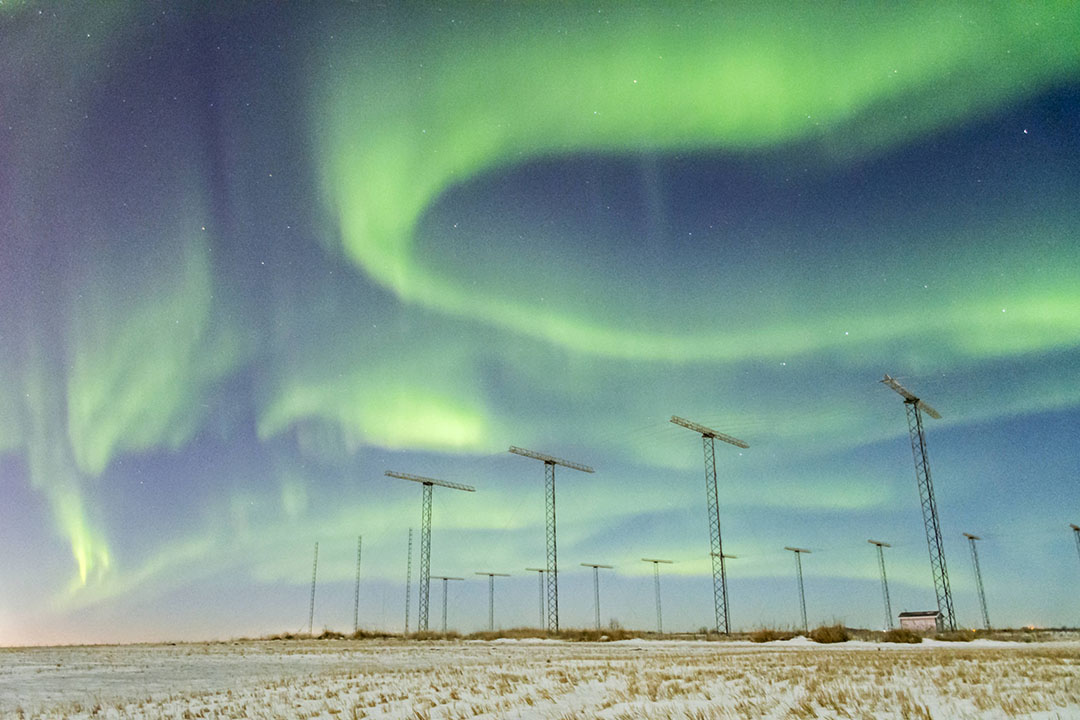
In addition, Canada has the largest land mass under the auroral oval, making it an ideal place to study solar-terrestrial interactions, says Dr. Hussey, explaining the connection between solar wind and the colourful lights we experience as auroras.
Solar wind is the result of the sun streaming charged particles outward from its corona at high speeds. The resulting plasma travels through the solar system, interacting with planets and other celestial bodies. Coming up against the natural protection of the Earth’s magnetic field, these particles are channelled along magnetic field lines toward the polar regions. There, they collide with atmospheric gases, resulting in the glow of the aurora borealis in the north and the aurora australis in the south.
Ionospheric research is looking to understand “how the Earth’s atmosphere responds to the violent bombardment of charged particles from the sun, and where all that energy goes,” says Dr Hussey. “A pilot would refer to the range we’re looking at – about 200 to 300 kilometres up – as space. But if you ask us, we see it as part of our atmosphere. We want to know what the weather is in space – and how it affects us on Earth.”
Made-in-Canada technology advancements
Of the over 40 SuperDARN radars worldwide, Canada operates five, located in Saskatchewan, B.C., the Northwest Territories and Nunavut.
SuperDARN radars emit high-frequency radio waves that refract in the upper atmosphere, bounce off targets made up of dense spots of plasma and return to radar receivers. Also called over-the-horizon radars, they can travel long distances parallel to the curvature of the Earth.
“When SuperDARN first started, everything was analog. Even today, many radars still use such systems,” says Dr. Billett, adding that SuperDARN Canada’s move from analog to digital came through a shift from aging hardware to modern software-defined radios (SDR) and digital signal processing.
Resulting technology advances come with improved data quality and reliability – as well as the ability to perform sophisticated tasks like full-field-of-view imaging and simultaneous multi-frequency operations.
“Previously, the signals from the 20 antennas were collapsed into only two data streams,” says Dr. Hussey. “The new system, which we call Borealis, processes all raw data streams independently. This very modern version of SuperDARN was developed by Kathryn McWilliams.
“Kathryn was a great scientist, and it is her legacy we’re continuing,” says Dr. Hussey of his predecessor, a trailblazing engineering physics professor at USask, who took over from Dr. Sofko as principal investigator and led SuperDARN Canada from 2012 until earlier this year.
Since it was designed with user-friendliness in mind, the Borealis system makes it easier to write experiments and use data, further enhancing accessibility for researchers, says Dr. Hussey. “We also have this mode, where we can capture 16 times more data, from once per minute to once every 3.7 seconds. This makes us very popular: lots of people want access to this information.”
An open-data policy ensures that data from all radars worldwide are shared by all SuperDARN partners and available to the public, he explains. “Combining data from all these radars – along with information from other types of instruments that study the aurora – allows us to picture what is happening globally.”
From big picture to local impact
The collaborative nature of the work at SuperDARN Canada illustrates one of the major strengths of the University of Saskatchewan, the Canadian lead for the international network, says Baljit Singh, the university’s vice-president, research. “We’re known for extensive international collaboration – and we focus on leadership in areas that address major global challenges, such as water and food security, vaccine development, public health, defence and sustainability.”

Canada’s contribution to SuperDARN is considerable, with five radars each scanning more than three million square kilometres every minute, 24 hours a day, 365 days a year. This continuous surveillance not only offers granular insights into how electromagnetic forces in space affect the Earth but also carries significant implications for defence and security in the Arctic.
Radars play a key role in monitoring aircraft signatures. In the polar regions, however, space weather – along with other radar signals – can make identifying and tracking targets more challenging, says Dr. Hussey. This resulted in a collaboration with Defence Research and Development Canada a few years ago, which continued periodically in the intervening years. A long-term goal is to continue this collaboration and implement AI-tools that will help filter radar data and provide easier identification in the High Arctic.
For Dr. Singh, SuperDARN Canada research also has implications at the community level. “The technologically driven world we live in is vulnerable to the effects of space weather, which can damage power grids and pipelines, degrade satellite navigation – and disrupt communications,” he says. “All of this can impact our daily lives and lead to loss of business and livelihoods, even loss of life in extreme situations.”
Some impacts of space weather have been well-documented. An example is the geomagnetic storm that led to the extensive failure of electrical systems on March 13, 1989, in Quebec, an event accompanied by intense auroras that could be seen as far south as Texas and Florida.
Dr. Hussey also recalls recent consequences affecting agricultural processes. “Due to a geomagnetic storm, radio signal transmissions from satellites were being distorted. It meant that precision-farming equipment that relies on GPS didn’t function well,” he says. “This can cause major disruptions, especially during planting or seeding times.”
Such examples inspire the question, “What can we do to better protect the digital communication assets and other infrastructure our society depends on?” says Dr. Singh. “That’s where research can provide valuable answers.”
The goal is not only to monitor space weather – but develop predictive capabilities that can minimize negative consequences, according to Dr. Hussey. Collaborations with SuperDARN scientists can allow satellite operators and space missions to take preventative measures in preparation of storms, such as putting satellites into low-energy mode to prevent damage to the electronics, he says. “Once satellites are in space, they’re very hard to fix.”
Yet despite significant advancements, “prediction remains very difficult in our field,” notes Dr. Billett. “We’re about 40 years behind weather forecasting on the ground, because we have much less information.
“We all have to work together to improve and ingest the data to try to understand the near-Earth space environment better,” he adds. And in this mission, SuperDARN Canada is leading the way.